

Backpacking One of Joshua Tree NP's Longest Trails - California Hiking & Riding Trail

Joshua Tree National park is a vast expanse of diverse desert biomes, sprawling almost 800,000 acres and just under 30 years old. It’s also a crucial part of the Mojave Desert ecosystem, housing numerous species of mammals, birds, insects and lizards. From palms to Joshua trees themselves, there’s no shortage of eco diversity to be ogled in this beautiful national park in California’s backyard.
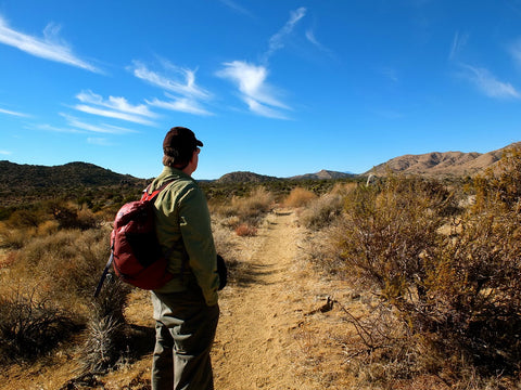
There’s also no shortage of scenic trails, each offering their own unique experience and sights. There are plenty of awesome moderate and beginner trails, campsites and backpacking routes, but today we’ll be looking at one of the longest, most intense backpacking trails the park has to offer: California Riding & Hiking Trail (CRHT).

California Riding and Hiking Trail
Prepare to be in good shape for this trek, as it totals out at 38 miles. You’ll be ascending about 3,000 feet, with the highest elevation being around 5,100 feet. The trail has been rated difficult and takes the average backpacker about two to four days to complete, and is considered a “mini thru-hike” of the entire park. The campsites along the way are said to feature captivating views and scenery, though the biggest obstacle on the trail will be navigating the terrain, conserving water and arranging for a shuttle (we’ll touch on that in a bit).
Hydration
There’s no water along the trail so you’ll be bearing the load of your reserves or caching it in the days leading up to your trip, as the National Parks Service recommends at least a gallon a day. Caching water is effectively storing it ahead of time to pick up during your hike. Any location that a road crosses the trail is a designated spot for folks to stash extra water. You can leave them on the ground next to informational boards, or hide it like some folks do. It’s a good idea to write your name and date on the gallons you cache behind.
Entering from the west entrance of the park, it’s recommended you cache your water eastbound. Here are the recommended points where it’s best to store water:
- Keys View Road
- Upper Covington Flats
- Juniper Flats
- Geology Tour Road
- Pinto Basin Road
Depending on how many days you plan on spanning your trip, you can gauge how many points along the way you’ll need to cache. Doing this can take anywhere 2-3 hours depending on the traffic in the park, which is usually a handful, so take this into account.
Whatever you do, please make sure you take your water jugs out with you, following Leave No Trace principles. You can shred them and add them to your regular trash for easy transportation. How To Wilderness explains some other tips and tricks to water caching HERE.

Transport
Since the trail is a point-to-point route from west to east, you’ll get to the start of the trailhead from Black Rock Campground. Doing the trail from west to east gives you a bit more downhill travel.
Folks usually leave a car at the end of the hike - the North Entrance Backcountry Lot - then arrange a shuttle to the trailhead by Black Rock Campground. However, cell service is rocky near the north entrance, so you should arrange for the ride ahead of time, while you’re en route to the entrance, even before.

Permits
Backcountry permits for backpacking the CHRT are fortunately free and easy to acquire - just fill one out at the backcountry board at the trailhead.
Be sure to fill one out for each vehicle that your group has!
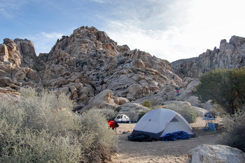
Camping
One of the best parts of this trail is getting to camp in the open, scenic wonder that is Joshua Tree National Park. Since the CHRT takes you off the beaten path of the park, you’ll want to opt for dispersed camping. If you don’t know what dispersed camping is, it just means camping on public land other than designated campgrounds - no reservations needed.
We advise camping at least a mile from a backcountry trailhead and a minimum of 500 feet from the trail - keep that environmental impact low. On that note, prepare to pack all your trash out and bring a trowel for waste pits which should be a considerable distance from trails and water sources.
On the trail, you will pass several more established campgrounds with primitive toilets. This is also a good chance to dispose of any trash or recycling.
While you aren’t permitted to have open fires, you can apply to use a camp stove using this form: https://permit.preventwildfiresca.org/
Store all of your gear inside your tents at night, since pesky dessert critters can nibble on your stuff, and there are scorpions in the area.

Navigation
The CRHT is pretty well-marked with trail signs and mile markers, and as you can probably assume, a compass and topographic map will be crucial.
Check out this super helpful map marked with a few of the aforementioned cache spots as well as suggestions for dispersed camping locations: https://caltopo.com/m/0SA0
The first six miles will be the biggest climb elevation wise followed by moderate ups and downs, but once you’re about halfway through the entire route (about 18 miles in) it’s practically downhill from there. In a good way, though! A 3,000 foot gain for 38 miles is quite modest.

Sun Protection
Joshua Tree is one of the most exposed parks out there, and UV rays forgive no-one. Choose an American Backcountry Long Sleeves tee for your hike. Not only are they lightweight and moisture-wicking, but they feature UPF 50+ solar protection that keeps the sun’s rays from penetrating through to your skin.
--
While it may be one of the longer more difficult routes the park has to offer, with the right amount of preparation and equipment, you’ll be set for the desert journey of a lifetime.
Share this blog with your travel crew and get them on board for a true California adventure!
Leave a comment